A major upgrade to Old Gympie Road
Old Gympie Road through Kallangur and Dakabin is used by more than 20,000 vehicles per day, and is going to get busier as our population grows. The area is also used by pedestrians, cyclists and other active transport users.
Some users are travelling to places along Old Gympie Road, like Kallangur State School, Dakabin Waste Management Facility, or local businesses. Others are using Old Gympie Road for longer trips to other areas. All of them need Old Gympie Road to be a safe and efficient transport route.
Council is upgrading Old Gympie Road to improve traffic flow and safety of all road users and pedestrians as our population grows. The upgrade aims to:
- reduce travel times and improve traffic flow
- create better and safer active transport options
- provide greener infrastructure and improved drainage
- reduce the risk of flooding on the road.
We shared the draft design for the upgrade between 27 October and 23 November 2025. Read what we heard here.
Detailed design
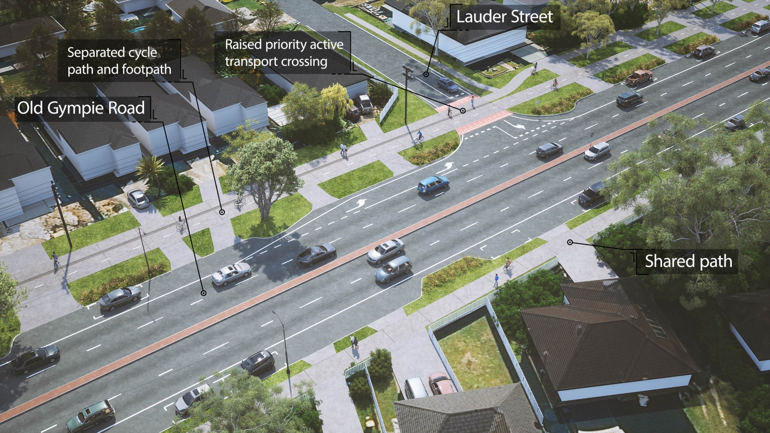
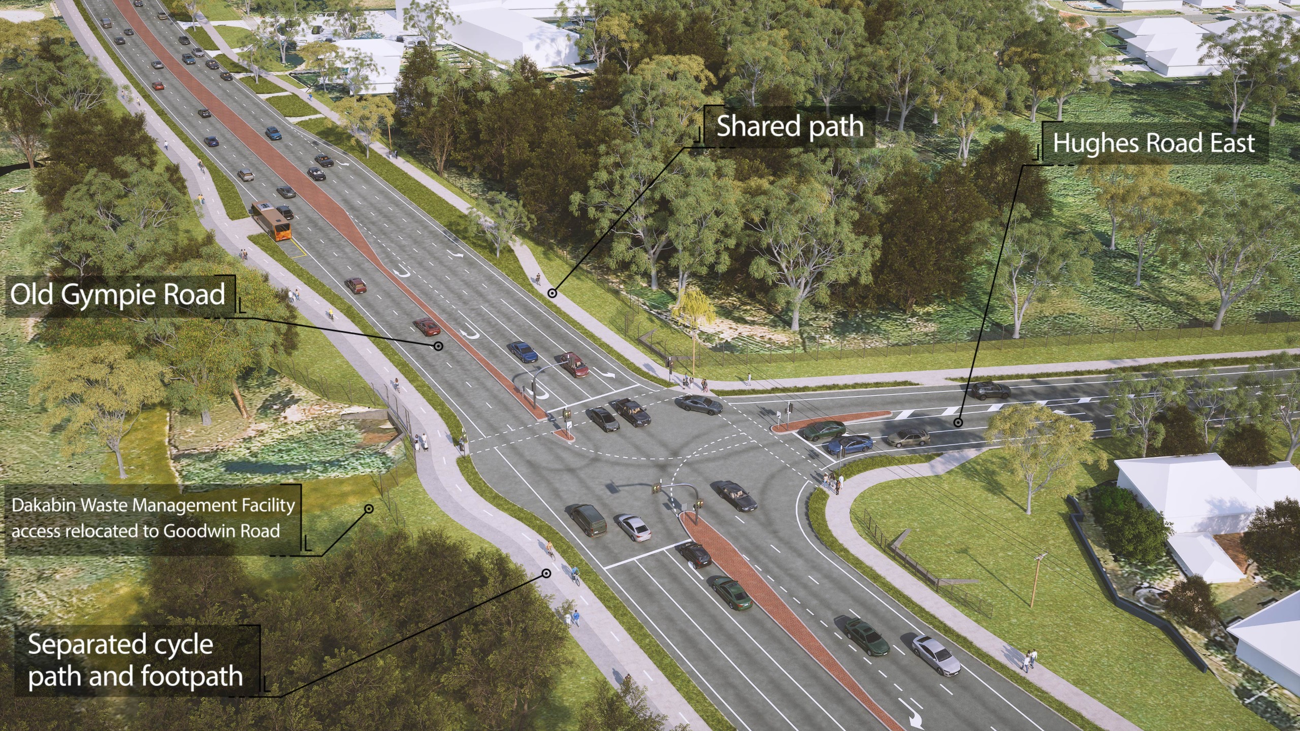
The detailed design for the Old Gympie Road – Anzac Avenue to Boundary Road upgrade includes:
- widening
the road to a four lane, median divided corridor with two lanes in
each direction
- installing
traffic lights at nine intersections
- new
footpaths, off-road active transport facilities and signalised pedestrian
crossings throughout the corridor
- new
seating and shelters at selected existing bus stops
- upgrading
the Fresh Water Creek crossing near Lillybrook Shopping Centre to
a bridge
- creating
a new entrance to the Dakabin Waste Management Facility from
Goodwin Road
- building
a separate off-road cycle track
- delivering new shared pathways, landscaping and street lighting.
We have been working with Kallangur State School and the Department of Education to reflect revised set down arrangements on Storey Road and extension to the existing car park on School Road. You can view the updated designs by clicking on the button below.
Before and after


Previous consultation
We previously consulted the community about our early planning for the upgrade to Old Gympie Road in 2021.
We considered this feedback to refine the design, which we then shared with the community for feedback between 27 October and 23 November 2025.
To read a summary of what we heard during this consultation, click here.
Next steps
We will use feedback from the community to refine the detailed design for the upgrade.
A number of services like powerlines, water and sewerage infrastructure and communications infrastructure will need to be relocated before we can start work on the road upgrades. Construction will only be able to start when all services have been relocated, which may take some time.
Updates about the project can be found on Council’s
website.
Collection notice
Moreton Bay City Council (Council) is collecting your personal information for the purpose of informing the Old Gympie Road (Anzac Avenue to Boundary Road) Upgrade project. Your responses will be shared with consultants supporting delivery of this project. Council will also use your contact information to update Council’s customer information records and to contact you about the Project and other functions, services and projects of Council. Council may use the information you provide to inform our other functions, services and projects.


